
Ramapo Previous Residents by Era
For a Ramapo address, the useful trail changes with the period. The modern tax roll, GIS map, and deed index establish the parcel now. Older work moves to the County Archives, library shelves, maps, and newspapers. A tax owner is not automatically the person who occupied the place, so past residents should be documented with the source that fits the question. The dates below are verified access points, not a promise that every name or address appears in every collection.
| Source | Years It Covers | Where Held | What It Shows |
|---|---|---|---|
| County Clerk deeds and land index | 1798 to present overall; 1798 to 1907 historical deed group | Rockland County Clerk eSearch and Archives | Recorded parties, transfer instruments, legal descriptions, and chain-of-title clues |
| County Clerk mortgages | 1798 to present route; 1798 to 1931 historical group | County Clerk and Archives | Mortgage, assignment, and satisfaction dates, rather than a sale by themselves |
| Ramapo assessment rolls | 1855 to 1964 historic; 2022 to 2026 current PDFs | County Archives and Ramapo Assessor | Tax owner, mailing and situs lines, value, and exemption context |
| Rockland census books | 1855 to 1925 | County Archives and the New City genealogy computer | A household and residence snapshot for an enumeration year |
| Directory anchors | 1926 Red Book; 1933/34 telephone book; other local runs not published | Suffern and New City collections; NYS Library listing | Address, occupant, or business clues that vary by edition |
| Suffern Sanborn map | October 1921, nine sheets | Library of Congress | Building footprint, use, and street relationship, not a resident list |
Start with the most recent source that identifies the exact parcel, then move back one transfer or one directory edition at a time. The Ramapo city directory collection is the better place to study the historical shelves themselves; here, the point is to use each dated entry as one link in an address history.
Ramapo Address Records Before the Past
Write the address as the current assessment roll shows it, then keep the situs line, owner or taxpayer line, mailing line, assessment year, and section-block-lot together. The section-block-lot, often shortened to SBL, is the parcel identifier that can survive a changed postal label or a missing street number in an old deed. Rockland County GIS accepts an address or Tax ID and adds parcel geometry, road context, municipal boundaries, and district layers. That map helps distinguish a delivery label from the government or parcel geography that controls the record.
Ramapo is especially prone to label confusion. A parcel can carry a Suffern, Monsey, Spring Valley, Hillburn, Sloatsburg, Pomona, Chestnut Ridge, New Square, or Tallman mailing label. Preserve that label instead of silently replacing it with a modern one. The assessor's owner and mailing address can differ from the parcel's situs, and a different mailing line is only a tax-record clue, not evidence that a person lived there.
- Situs address
- The physical parcel address used in an assessment or map record.
- Section-block-lot
- The tax-map parcel identifier used to connect assessment, map, permit, and deed materials.
- Legal description
- The deed's parcel description, such as metes and bounds or a subdivision lot, which can outlast a street-label change.
- Chain of title
- The sequence of recorded transfers that connects one deed party to an earlier one.
Note: A historic Ramapo, village, or turnpike label is a research fact worth retaining beside the current USPS-style address.
Ramapo Deed Records Backward
The Rockland County Clerk's document system supplies the formal ownership trail. Begin with the current tax owner and SBL, then search that owner as a grantee near the likely purchase date. Capture the grantor, recording date, document or book and page number, legal description, and any prior-deed reference. Next, search the grantor as a grantee in an earlier period. Repeating that sequence moves backward through recorded conveyances without assuming that a mortgage or mailing address proves residence.
- Confirm the parcel in the Ramapo assessment roll and Rockland GIS, recording both the SBL and the exact situs line.
- Use the County Clerk digital document system to find the current owner as grantee around the acquisition period.
- Copy the deed's grantor, recording date, legal description, and document reference before opening another result.
- Search that grantor as an earlier grantee, preserving trusts, estates, and entity names exactly as recorded.
- When the online trail stops, ask the Clerk or Archives for the book, index, map, or prior-deed reference that bridges the next period.
A grantor conveys an interest; a grantee receives it. Mortgages, assignments, and satisfactions are useful dated financing records, but they are not transfers. Old deeds may never state a familiar street number. In that case, the legal description, adjacent owner, map number, road name, and SBL are the bridge back to the Ramapo address.
Guest viewing in eSearch is free. Printing requires an account and costs $0.50 per page; prepaid-account funding carries a 3% convenience charge. Those access details matter when several deeds need to be compared in sequence.
Ramapo Archives for Address Records
Rockland County's 1798 formation creates a clear starting point for the oldest county land trail. The Archives reports original historical deeds from 1798 to 1907, mortgages from 1798 to 1931, Ramapo tax and assessment rolls from 1855 to 1964, census books from 1855 to 1925, and naturalization papers from 1812 to 1991. These records are the fallback when an online result is thin or a legal description no longer matches a modern street line.
Rockland County Archives is at 50 Sanatorium Road, Building S, Pomona, and lists weekday hours of 9 a.m. to 5 p.m. Historic files are viewed as research material and should be confirmed before travel. Bring the document reference, SBL, street variants, date range, and names from the last verified deed. A narrow request lets staff identify the relevant index or map shelf without treating the address as a single fixed label.
Ramapo was known as Hempstead until 1829. Older Orange and Rockland geography can also overlap in family research. County map checkpoints include the 1876 Rockland Atlas, the 1891 Hudson Valley Atlas, and the 1798 to 1940 map index. They help place a lot or road name before trying to assign a modern number.
Ramapo Household Records in Directories
Deeds identify recorded parties, not every household. To find who lived here before, pair a deed interval with the Suffern Free Library Ramapo Room, the New City Library Rockland Room, and County Archives census books. The verified local anchors are the 1926 Rockland County Red Book and Classified Directory, a Rockland County telephone book for 1933/34 listed by the NYS Library, and city-directory holdings at Suffern whose complete year run is not published. Each entry should be copied exactly, including street spelling and post-office label.
- Choose a directory or telephone-book edition close to the transfer or assessment year.
- Read its abbreviation key and look for the address in any reverse or criss-cross section.
- Check the alphabetic entry for the same name, spouse notation, business affiliation, or occupancy mark.
- Pair the result with the 1855 to 1925 County census books or released federal schedules, then compare the address with the parcel trail.
- Use a newspaper notice, obituary, probate file, or later deed as a dated endpoint, rather than treating an old listing as current.
The Ramapo Room holds city directories, historical census information, old newspapers, maps, clippings, and a complete Journal News microfilm file. The Rockland Room offers countywide history and genealogy material. For a former resident who did not own the parcel, this household trail can be stronger than the deed chain.
Lawful use. Ramapo house-history research is appropriate for family history, estate work, and personal curiosity. Do not use historical findings to watch, contact, harass, or endanger a living person.
Ramapo Address Records Dated by Maps
Building and map evidence can place a change in time even when no resident name appears. Ramapo's Building, Planning & Zoning forms use legal address, SBL, nearest cross street, current land use, proposed work, owner or agent, and contractor information. No public online issued-permit index was located, so request the permit, certificate of occupancy or use, complaint, or enforcement file by exact address, SBL, and year range. A dated project file can explain when a building changed, but it does not establish a household by itself.
Rockland GIS lists historic aerial coverage for 1958, 1969–70, 1974, 1975–77, 1984 color, 1987, 2000 color, and 2001 color infrared. For central Suffern, the Library of Congress provides a nine-sheet October 1921 Sanborn map. Aerials and Sanborn sheets can show a road alignment, subdivision, building footprint, or use. Pair them with a directory, deed, or newspaper before adding an occupant to the address story.
Note: No official Ramapo street-renumbering or renaming project with a date was located, so continuity should be demonstrated with maps and parcel identifiers.
Ramapo Deed Records for Prior Residents
The Rockland County Clerk eSearch screen is the first official online stop for a deed-chain check. Use it to locate a document reference and then compare the recorded party roles and legal description across each transfer.
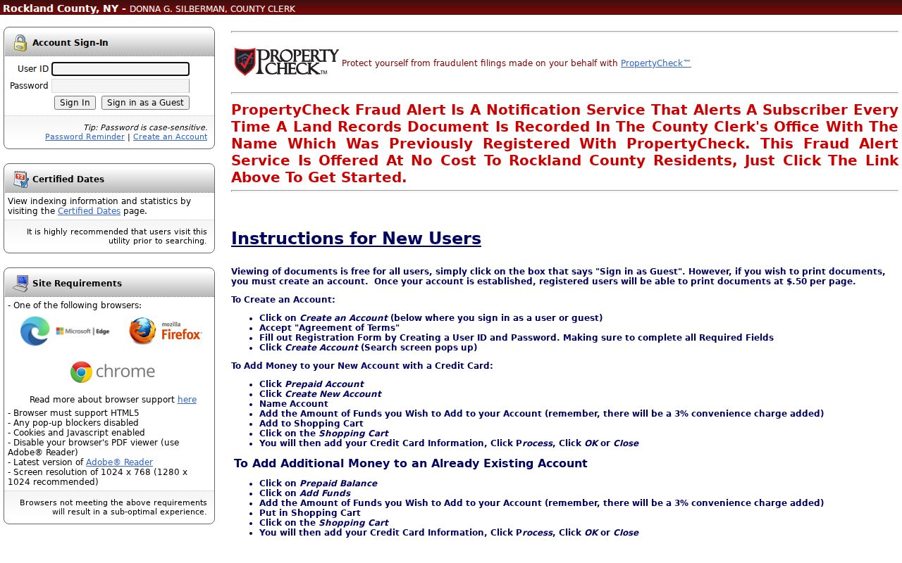
The guest and account paths shown here reflect the important access split: document viewing is available to guests, while printing follows the account and page-fee route. The image is a portal starting point, not proof that a party was a Ramapo occupant.
Ramapo Address Records Compared
Recorded-name changes can affect a house-history trail and deserve verification. The County Clerk's eSearch screen promotes PropertyCheck Fraud Alert, a no-cost service that notifies a subscriber when a land-record document is recorded with a registered name. It is useful for recognizing a new filing, but it does not block a filing or certify ownership. Confirm any unexpected alert with the Clerk and the underlying record before making conclusions about a Ramapo parcel.
| Record type | Strongest answer | What it cannot settle alone |
|---|---|---|
| Assessment roll | Tax identity, SBL, situs, mailing line, and annual context | Whether the tax owner occupied the parcel |
| Recorded deed | Transfer parties, date, and legal description | Who made up the household at the address |
| Directory or census entry | A dated household or address clue in that edition or enumeration | Legal ownership on the publication or census date |
| Aerial or Sanborn map | Building, road, or subdivision context | A person's connection to the property |
For a long address history, keep a simple source log: assessment year, SBL, situs spelling, deed reference, party role, map or directory edition, and custodian. That log separates a proved recorded transfer from a household clue and makes a later correction possible when a road name, postal label, or parcel description changes.